
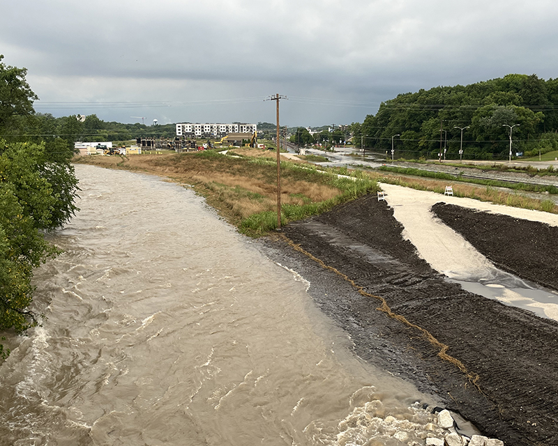
When the Menomonee River crested early Aug. 10 at 14.5 feet, one of the highest levels ever recorded, the resulting floodwaters blanketed much of the public infrastructure and recreational facilities on the banks of the river in Tosa Village, creating what to many seemed an unprecedented natural disaster in the heart of the city.
And yet, with some some preliminary assessments of damage in the village reported to be less severe than expected, the dramatic filling of the flood plain on Aug. 10 may have demonstrated what decades worth of flood mitigation projects were designed to do — minimize the damage to homes and businesses.
"There's no question that the investments made in these flood management projects had significant benefit," Bill Graffin, public information manager for the Milwaukee Metropolitan Sewerage District, said in a phone interview with Tosa Forward News about the role those projects played in limiting the impact of the flooding Menomonee.
In particular, Graffin credited two major infrastructure projects in Wauwatosa that were facilitated several years ago by MMSD for helping to contain the recent river flood: Hart Park and the County Grounds basins behind Hoyt Park.
Some of the most visually dramatic flooding was at Hart Park, which was almost entirely underwater for much of the morning Aug. 10. The flood ruined the football stadium's playing field, though comprehensive estimates of the damage to the city-owned park weren't immediately available. Even so, Hart Park's current design was intended to take on massive amounts of water in such an event, Graffin said.
After major floods in that area in 1997 and 1998, MMSD worked with Wauwatosa officials and residents to buy and clear homes from a former neighborhood at that location and expand Hart Park's footprint from 20 to 50 acres while also adding a series of levees to contain water when the river rises sharply. The project was completed in 2007 at a cost of $48 million.
“Hart Park did exactly what it was built to do, to take in water,” Mayor Dennis McBride told WTMJ-AM. “That likely saved much of downtown from more serious flooding.”
McBride echoes how MMSD describes Hart Park's role in mitigating floods.
"The park itself actually stores floodwater until the Menomonee River recedes to lower flow conditions after a storm," MMSD says in its online description of the Hart Park expansion. "The park will remain dry the vast majority of the time, except when strong storms cause flooding in the Menomonee River. Hart Park is designed to work along with three other projects on the Menomonee River to harness and protect against the one percent probability flood, commonly called the 100-year flood."
Graffin said the weekend storm likely did produce what is colloquially known as a "100-year flood," though that description is something of a misnomer. It does not precisely refer to the time between such severe floods but rather the probability of one happening in any given year. The odds of a "100-year flood" are 1%, though those odds could be increasing with severe weather patterns fueled by climate change.
That also is why public projects like the Hart Park expansion are good investments, Graffin said. He added that he was impressed at how much water from the storm overnight Aug. 9 was diverted and contained by another MMSD project upstream, the County Grounds basin.
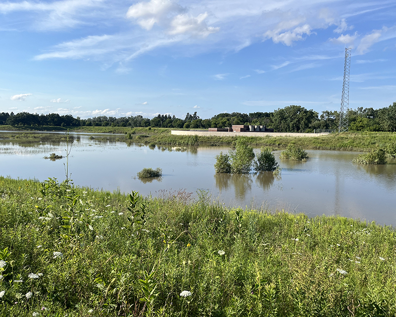
Underwood Creek flows into the Menomonee River near Hoyt Park. To keep creek water from exacerbating flooding downriver, MMSD created a large basin of 65 acres that is bisected by the Swan Boulevard bridge. Thanks to the $90 million project, the basin now can hold up to 315 million gallons of water in an extreme rainstorm, and the system is designed to keep it there for release when the water level of the Menomonee River drops.
Rainwater collects in the basin after passing from Underwood Creek through a half-mile long tunnel 17-feet in diameter. "From there it will slowly release into the Menomonee River," MMSD says on its website. "During extreme storms, the basin could fill in about four hours. If completely filled, it can take four days to drain into the river."
More than 5 inches of rain fell on Wauwatosa in just five hours overnight Aug. 9. Photos of the County Grounds basin during the next morning's flooding show the basin was full or nearly full — again, a sign that the infrastructure projects worked as designed, Graffin said.
MMSD also conducted a third flood management project east of Hart Park and farther down the Menomonee River, along State Street. That project has been undertaken over several years and multiple phases, the first of which was completed in 2010.
In the most recent phase, in the area near Hawley Road, an unused bridge crossing the river was removed, the river banks were shifted and fortified, and a large levee was built up. Though the latest phase of the project is not yet complete and the neighborhood experienced some flooding during the recent storm, MMSD has said the improvements will work with the other projects upstream to mitigate the severity of flooding for years to come.
A fourth project on the Menomonee River was completed earlier, in 2001, in Milwaukee's Valley Park neighborhood, also known as Piggsville. That neighborhood was also hit hard by the 1997 and 1998 floods and has benefited since then from MMSD's flood mitigation projects along the river there, Graffin said.
Graffin cautioned that it was too early to say precisely how much role the flood control infrastructure played in the way the flooding evolved, though MMSD will be conducting analysis in the aftermath to see if any further improvements are warranted.
"With climate change and stronger storms coming at us, we’ve got to make sure our infrastructure is ready to handle some of these bigger, intense storms," he said.
Get additional Tosa Forward News coverage of the 2025 flood here.


