
Even Wauwatosa residents who have lived in the city for decades described the weekend flooding of the Menomonee River as one of the worst they could recall, and figures tracked by the U.S. Geological Survey show just how historic this flood was.
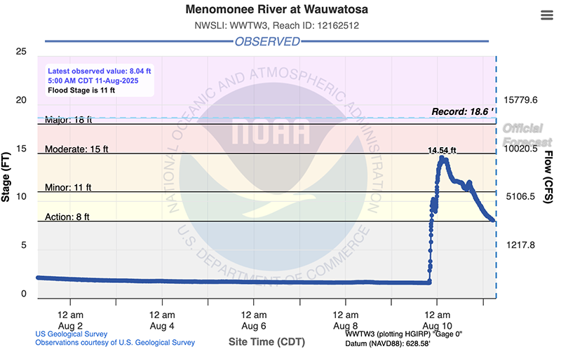
The river crested at 14.54 feet, a rise of about 13 feet over just six hours overnight Aug. 9 as a severe storm dropped torrential rain totaling more than 5 inches on Wauwatosa. The peak flood level occurred at 2:15 a.m. Aug. 10 and has gradually subsided since then, according to the USGS data.
As day broke Aug. 10, with the river level on the decline, it continued to cover a large flood plain in Tosa Village that included most of Hart Park, the parking lot under the Harmonee Bridge, the municipal lot that is home to Tosa Farmers Market on Saturdays and much of the railroad right-of-way parallel to State Street.
A day later, on Aug. 11, the river was officially back below flood stage but still well above normal levels at about 8 feet. For comparison, the river level was about 1.5 feet just before the storm.
As severe as the flooding was from the storm, the river's rise didn't quite break a record. That historic high mark was the 18.6-foot crest set on June 21, 1997. The river crested nearly as high the next year, reaching 18.3 feet on Aug. 6, 1998, according to the USGS data.
Those back-to-back flood years of 1997 and 1998 were the catalyst for redevelopment of the Hart Park neighborhood. Homes in the flood plain neighborhood were purchased and razed to expand the park as part of a broader flood-mitigation effort in which the city partnered with FEMA and the Milwaukee Metropolitan Sewerage District.
This year, the recent crest of the Menomonee River ranks the flood as the river's sixth highest in Wauwatosa. The only other higher river crests occurred on June 7, 2008 (15.68), June 19, 2009 (15.34) and July 22, 2010 (14.65).
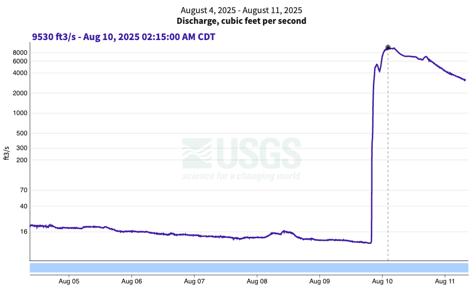
As for the volume of water flowing through Tosa Village, it was immense. From last week's low of about 10 cubic feet per second during the previous dry spell, the region's large amount of rainfall in such a short period of time overnight Aug. 9 sent nearly 10,000 cubic feet of water per second through the village. It's peak at 2:15 a.m. Aug. 10 was about 9,500 cubic feet per second.
As the river level has dropped back below flood stage, the Menomonee continues to flow at unusually high volume. As of 8 a.m. Aug. 11, it was still registering 3,090 cubic feet per second.
Get additional Tosa Forward News coverage of the 2025 flood here.


